![](/images/other/stat-length.png)
![Tour Wandern Le Boulou - 20130219 boucle au Boulou - Photo](https://media.geolcdn.com/t/1900/400/5f1eba6d-668a-4c54-95e1-6bd5d7227d80.jpg&format=pjpeg&maxdim=2)
20130219 boucle au Boulou
ThonyM
Benutzer
![Länge](/images/other/stat-length.png)
Länge
10,4 km
![Maximale Höhe](https://static1.geolcdn.com/siteimages/upload/files/1508320355ic_sort_altitude_max_24dp.png)
Maximale Höhe
369 m
![Positive Höhendifferenz](https://static1.geolcdn.com/siteimages/upload/files/1508320355ic_sort_den_pos_24dp.png)
Positive Höhendifferenz
450 m
![Km-Effort](/images/other/stat-length.png)
Km-Effort
16,4 km
![Min. Höhe](https://static1.geolcdn.com/siteimages/upload/files/1508320355ic_sort_altitude_min_24dp.png)
Min. Höhe
96 m
![Negative Höhendifferenz](https://static1.geolcdn.com/siteimages/upload/files/1508320355ic_sort_den_neg_24dp.png)
Negative Höhendifferenz
454 m
![Boucle](https://static1.geolcdn.com/siteimages/upload/files/16400158638029165_repeat_loop_refresh_sync_direction_icon.png)
Boucle
Ja
Erstellungsdatum :
2023-02-19 08:16:11.0
Letzte Änderung :
2023-02-19 12:26:56.093
![Wandern](https://static1.geolcdn.com/sitytour/trail-icons/101.png)
3h00
Schwierigkeit : Medium
![Scannen Sie diesen QR-Code, um die Tour in der SityTrail-Anwendung zu öffnen](https://capi.geolives.com/qq0zvz2zws4bq2lad0pu/sitytour/trails/3557368/qr.png?size=200)
Kostenlosegpshiking-Anwendung
Über SityTrail
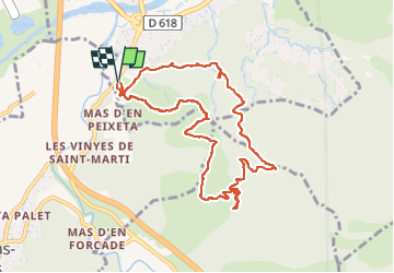
Tour Wandern von 10,4 km verfügbar auf Okzitanien, Ostpyrenäen, Le Boulou. Diese Tour wird von ThonyM vorgeschlagen.
Beschreibung
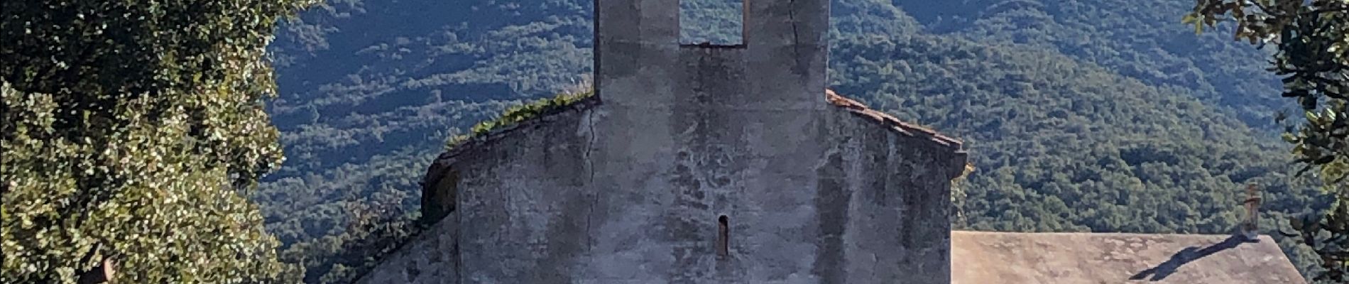
L’accès à La Chapelle est interdit au public . Le proprio nous a dit qu’il n’aimait pas voir du monde autour. Construite au Xieme siècle
Ort
Land:
France
Region :
Okzitanien
Abteilung/Provinz :
Ostpyrenäen
Kommune :
Le Boulou
Standort:
Unknown
Gehen Sie:(Dec)
Gehen Sie:(UTM)
485890 ; 4706428 (31T) N.
Kommentare
Touren in der Umgebung
![Tour Wandern Le Boulou - rando de la bataille du Boulou - Photo](https://media.geolcdn.com/t/375/260/aa2b3d38-bac5-4589-a4ac-8bd34f744e79.jpg&format=jpg&maxdim=2)
![Wandern Wandern](https://static1.geolcdn.com/sitytour/trail-icons/101.png)
rando de la bataille du Boulou
Wandern
Sehr schwierig
(1)
Le Boulou,
Okzitanien,
Ostpyrenäen,
France
![](/images/other/stat-length.png)
8,4 km | 10,5 km-effort
3h 27min
![](https://static1.geolcdn.com/siteimages/upload/files/16400158638029165_repeat_loop_refresh_sync_direction_icon.png)
Ja
![Tour Wandern Les Cluses - LES CLUSES 66 - Photo](https://media.geolcdn.com/t/375/260/ext.jpg?maxdim=2&url=https%3A%2F%2Fstatic1.geolcdn.com%2Fsiteimages%2Fupload%2Ffiles%2F1553511878bg_sport_marche.png)
![Wandern Wandern](https://static1.geolcdn.com/sitytour/trail-icons/101.png)
LES CLUSES 66
Wandern
Einfach
(10)
Les Cluses,
Okzitanien,
Ostpyrenäen,
France
![](/images/other/stat-length.png)
9,4 km | 12,8 km-effort
1h 50min
![](https://static1.geolcdn.com/siteimages/upload/files/16400158638029165_repeat_loop_refresh_sync_direction_icon.png)
Ja
![Tour Wandern Saint-Jean-Pla-de-Corts - 66 ST-JEAN-PLA-DE-CORTS, promenade autour du Tech, jusqu'au BOULOU - Photo](https://media.geolcdn.com/t/375/260/ext.jpg?maxdim=2&url=https%3A%2F%2Fservices.sitytrail.com%2FGeolivesWS%2FDownloadMedia.ashx%3FTrailID%3D519982%26Media%3D20160131140429.jpg)
![Wandern Wandern](https://static1.geolcdn.com/sitytour/trail-icons/101.png)
66 ST-JEAN-PLA-DE-CORTS, promenade autour du Tech, jusqu'au BOULOU
Wandern
Einfach
(1)
Saint-Jean-Pla-de-Corts,
Okzitanien,
Ostpyrenäen,
France
![](/images/other/stat-length.png)
7,9 km | 8,8 km-effort
1h 18min
![](https://static1.geolcdn.com/siteimages/upload/files/16400158638029165_repeat_loop_refresh_sync_direction_icon.png)
Ja
![Tour Wandern Maureillas-las-Illas - CERET 66 - les hauts de CERET - ballade en bas Vallespir - dolmen de la Siureda torre Bel Ull - Photo](https://media.geolcdn.com/t/375/260/ext.jpg?maxdim=2&url=https%3A%2F%2Fservices.sitytrail.com%2FGeolivesWS%2FDownloadMedia.ashx%3FTrailID%3D451637%26Media%3D20150729193430.jpg)
![Wandern Wandern](https://static1.geolcdn.com/sitytour/trail-icons/101.png)
CERET 66 - les hauts de CERET - ballade en bas Vallespir - dolmen de la Siure...
Wandern
Medium
(1)
Maureillas-las-Illas,
Okzitanien,
Ostpyrenäen,
France
![](/images/other/stat-length.png)
6,5 km | 9,9 km-effort
1h 24min
![](https://static1.geolcdn.com/siteimages/upload/files/16400158638029165_repeat_loop_refresh_sync_direction_icon.png)
Ja
![Tour Wandern Montesquieu-des-Albères - MONTESQUIEU-DES-ALBERES 66 - Les Agouillous - les chemins de l'eau dans les Albères - Photo](https://media.geolcdn.com/t/375/260/ext.jpg?maxdim=2&url=https%3A%2F%2Fservices.sitytrail.com%2FGeolivesWS%2FDownloadMedia.ashx%3FTrailID%3D451257%26Media%3D20150728182708.jpg)
![Wandern Wandern](https://static1.geolcdn.com/sitytour/trail-icons/101.png)
MONTESQUIEU-DES-ALBERES 66 - Les Agouillous - les chemins de l'eau dans les A...
Wandern
Medium
(1)
Montesquieu-des-Albères,
Okzitanien,
Ostpyrenäen,
France
![](/images/other/stat-length.png)
12,7 km | 13,9 km-effort
2h 16min
![](https://static1.geolcdn.com/siteimages/upload/files/16400158638029165_repeat_loop_refresh_sync_direction_icon.png)
Ja
![Tour Wandern Le Boulou - LES THERMES DU BOULOU - 66 - Albera viva - PUIG de l'Estella - Photo](https://media.geolcdn.com/t/375/260/ext.jpg?maxdim=2&url=https%3A%2F%2Fservices.sitytrail.com%2FGeolivesWS%2FDownloadMedia.ashx%3FTrailID%3D443397%26Media%3D20150709200943.jpg)
![Wandern Wandern](https://static1.geolcdn.com/sitytour/trail-icons/101.png)
LES THERMES DU BOULOU - 66 - Albera viva - PUIG de l'Estella
Wandern
Medium
(2)
Le Boulou,
Okzitanien,
Ostpyrenäen,
France
![](/images/other/stat-length.png)
7,3 km | 11,4 km-effort
1h 32min
![](https://static1.geolcdn.com/siteimages/upload/files/16400158638029165_repeat_loop_refresh_sync_direction_icon.png)
Ja
![Tour Wandern Le Boulou - Bataille du Boulou (1793 - 1794) - Photo](https://media.geolcdn.com/t/375/260/e8fd6dc5-027d-40cc-9239-020c7f056093.jpg&format=jpg&maxdim=2)
![Wandern Wandern](https://static1.geolcdn.com/sitytour/trail-icons/101.png)
Bataille du Boulou (1793 - 1794)
Wandern
Sehr leicht
Le Boulou,
Okzitanien,
Ostpyrenäen,
France
![](/images/other/stat-length.png)
10,4 km | 13,2 km-effort
1h 57min
![](https://static1.geolcdn.com/siteimages/upload/files/16400158638029165_repeat_loop_refresh_sync_direction_icon.png)
Ja
![Tour Hybrid-Bike Le Boulou - Autour du Boulou (66) - Photo](https://media.geolcdn.com/t/375/260/1d105df1-7b05-435b-be16-23a1a2dd8321.jpg&format=jpg&maxdim=2)
![Hybrid-Bike Hybrid-Bike](https://static1.geolcdn.com/sitytour/trail-icons/203.png)
Autour du Boulou (66)
Hybrid-Bike
Einfach
Le Boulou,
Okzitanien,
Ostpyrenäen,
France
![](/images/other/stat-length.png)
17 km | 19,5 km-effort
1h 54min
![](https://static1.geolcdn.com/siteimages/upload/files/16400158638029165_repeat_loop_refresh_sync_direction_icon.png)
Nein
![Tour Wandern Le Boulou - Pic Estelle (377m) - Le Boulou - Pyrénées orientales (66) - Photo](https://media.geolcdn.com/t/375/260/e232faca-0036-4399-b7af-e7d27b87588b.jpg&format=jpg&maxdim=2)
![Wandern Wandern](https://static1.geolcdn.com/sitytour/trail-icons/101.png)
Pic Estelle (377m) - Le Boulou - Pyrénées orientales (66)
Wandern
Sehr leicht
Le Boulou,
Okzitanien,
Ostpyrenäen,
France
![](/images/other/stat-length.png)
10,9 km | 15,9 km-effort
2h 19min
![](https://static1.geolcdn.com/siteimages/upload/files/16400158638029165_repeat_loop_refresh_sync_direction_icon.png)
Ja